
State bird
Yellowhammer (northern flicker)
Sources: Designation & background

The Yellowhammer State
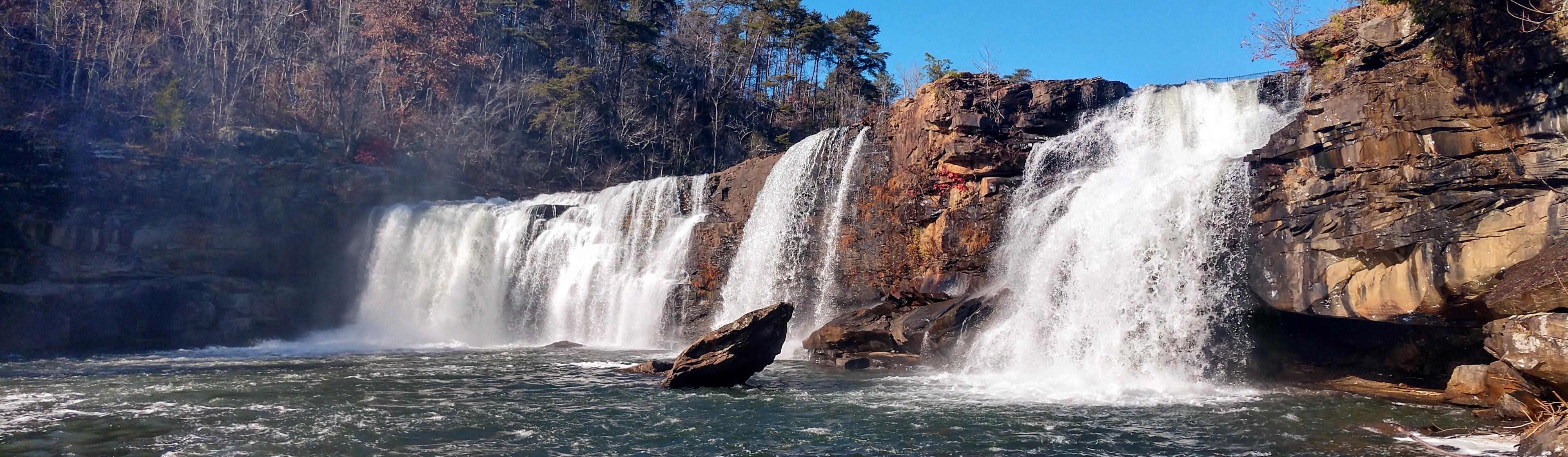
Little River flows for much of its course along the top of Lookout Mountain before cutting through a sandstone canyon.
Sources: Census · population · Census · area
Yellowhammer (northern flicker)
Sources: Designation & background
Alabama
Sources: Designation & background
Lane cake
Sources: Designation & background
Neighboring states: Florida, Georgia, Mississippi, Tennessee.
Little River flows for much of its course along the top of Lookout Mountain before cutting through a sandstone canyon. Waterfalls, forested slopes and exposed rock illustrate Alabama’s Appalachian uplands, a different landscape from its Gulf Coast.
The total area includes 131,171 km² of land and 4,597 km² of water, according to Census area measurements.
A crimson diagonal cross on a white field.
Sources: Census · geographic reference · Census · area measurements · National Park Service · Little River Canyon
A canyon is evidence of a river doing work over time: flowing water wears away and carries off rock and sediment. At Little River Canyon, the exposed cliffs and changes in elevation help explain waterfalls and the route of the stream. This upland landscape is a useful correction to thinking of Alabama only as a coastal state. A state boundary can contain several very different physical regions.
The right to vote existed in law, but discriminatory registration practices and intimidation kept many Black Alabamians from exercising it. Local organizers and national civil rights groups made Selma a center of the campaign to secure federal protection for voting rights.
On March 7, 1965, state troopers and local officers attacked marchers crossing the Edmund Pettus Bridge on their way toward Montgomery. Images of the violence, known as Bloody Sunday, brought national attention to the campaign. A later march reached Montgomery under federal protection. President Lyndon Johnson signed the Voting Rights Act in August, giving the federal government stronger tools to challenge racial discrimination in voting.
Read more: Historical source ↗
The central problem at Selma was the gap between a right written into law and the ability to exercise it. Registration barriers could exclude voters even without a law simply announcing that Black citizens could not vote. Marching brought that local problem to national attention. Federal voting-rights protections mattered because leaving enforcement entirely to the same local institutions could allow the barriers to continue.
Sources: Congressional Research Service · statehood · U.S. Census Bureau · historical geography · National Park Service
The Poarch Band of Creek Indians is a living tribal community in Alabama. Its own account of its history and government adds a present-day perspective alongside the state’s civil rights and settlement histories.
Continue with Poarch Band of Creek Indians. This is one starting point, not a complete account of the peoples connected to this land.
| Measure | Alabama | Florida |
|---|---|---|
| Population (2025) | 5,193,088 | 23,462,518 |
| Land area (km²) | 131,171 | 138,887 |
| People per km² of land | 39.6 | 168.9 |
Florida has more people per square kilometer of land. Population density divides population by land area. It is an average across the whole jurisdiction, not a claim that residents are evenly spread out.
Calculated from the Census population series and land-area measurements used on these pages. Rounded figures; water area is excluded. Explore Florida.
In 2025, manufacturing was the largest of the broad industry groups compared here by current-dollar output. Other major groups included government and government enterprises, real estate and rental and leasing, and professional and business services.
Total economic output was $341.2 billion in current dollars in 2025.
Share of total current-dollar GDP. These figures measure output, not employment.
Sources: BEA · annual GDP by state, SAGDP2
The industry chart measures the value of production. It does not count workers. An industry with a large share of GDP need not employ the most people or pay the highest wages. Employment and wage data would be needed to answer those questions.
July 1 resident population estimates, using the Census Bureau’s Vintage 2025 series.
Sources: U.S. Census Bureau
| Year | People |
|---|---|
| 2020 | 5,032,962 |
| 2021 | 5,050,058 |
| 2022 | 5,076,868 |
| 2023 | 5,117,850 |
| 2024 | 5,163,055 |
| 2025 | 5,193,088 |
Real GDP measures economic output adjusted for inflation. The chart uses BEA’s chained 2017 dollars.
Sources: U.S. Bureau of Economic Analysis
| Year | Millions of chained 2017 dollars |
|---|---|
| 2010 | 199,455.0 |
| 2011 | 201,372.8 |
| 2012 | 203,675.5 |
| 2013 | 206,962.9 |
| 2014 | 206,070.0 |
| 2015 | 208,950.3 |
| 2016 | 212,862.8 |
| 2017 | 216,615.5 |
| 2018 | 220,808.8 |
| 2019 | 225,272.8 |
| 2020 | 223,025.5 |
| 2021 | 233,951.1 |
| 2022 | 239,846.6 |
| 2023 | 248,313.7 |
| 2024 | 255,629.4 |
| 2025 | 260,648.0 |
Alabama’s population increased by about 3.2% between 2020 and 2025 in this series. That shows the size of the change. The chart alone cannot tell us how much came from births, deaths or migration.
Real GDP adjusts for changes in prices, so it helps compare production over time. Current-dollar GDP includes price changes. Neither measure tells us how income is distributed among residents.
Electoral votes equal the state’s U.S. House seats plus its two U.S. Senate seats. These allocations apply to the 2024 and 2028 presidential elections.
Use the explanations and data on this page to answer ten questions. Hints and links to the relevant sections are available throughout.
Your place in the quiz and best full-quiz score are saved on this device when browser storage is available.
Want to practice recognizing states? Try the mixed-state map quiz.
Narrative and quiz updated 5 October 2026. Statistical data prepared 27 September 2026. Population: Census Bureau Vintage 2025, July 1 estimates for 2020–2025. Real GDP: BEA annual state accounts, SAGDP9, millions of chained 2017 dollars; industry shares: SAGDP2, current dollars. Data downloaded 27 September 2026. Area measurements include land and water.
Sources: Census · population estimates · BEA · state GDP · Census · area measurements · Natural Earth · map data
The capital clock shows current local time. Statistical figures are dated estimates and may be revised.
Updated 29 October 2026. Statistics retain the dated series shown in the charts; these are not live figures. Sources are linked beside each topic.